Charlotte’s Declining Tree Canopy Hides Years Of Loss In Historically Black Neighborhoods
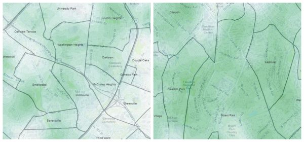
New analyses conducted by the Center of Applied GIS reveals less access to urban tree canopy in many of Charlotte’s underserved nieghborhoods. These findings contexualize a study by UVM’s Spatial Analysis Lab (here) that found the majority of tree loss in Charlotte between 2012 and 2018 occured in more affluent nieghborhoods, likely caused by storm damage, disease and homeowner management. However, losses where not as significant in many “crescent” nieghborhoods as they did not have as much tree canopy to start with.
Overall, urban tree canopy in the City declined from 49% to 45%, challenging Charlotte’s stated goal of “50% by 2050.”
The uneveness of access to canopied areas was revealed by maps that measured how much tree cover would an observer encounter from any given point during a 1/4 mile walk. Urban planners typically reference that distance as a reasonably walkable.
The maps, available here in an interactive GIS, show many residential areas with less shade, areas that may have increased health impacts according to Dr. Cheryl Courtlandt, a pediatrician and asthma specialist with Atrium Health Levine Children’s. You can read Michael Falero’s story for WFAE here.