GIS Day 2016 at UNC Charlotte emphasized the value of “Spatial Thinking”
GIS Day 2016 at UNC Charlotte
UNC Charlotte’s hosting of GIS Day 2016 celebrated all things GIS. The theme that emerged over the course of day was “Spatial Thinking”, a concept that reflects a growing consensus that the utility of GIS in solving problems is only limited by the imagination of users and practitioners. Events ranged from a panel discussion around the topics of innovation in GIS and skills development in the emerging workforce, to a demonstration of balloon mapping. Lightning talks by students and practitioners were “standing room only” and included new ways to explore cities using maps generated by Twitter feed; a case study that mapped environmental justice issues, and new applications to reduce risks associated with natural catastrophes.
We thank our sponsors for helping make GIS Day a great success:
BeaconGIS ESRI UNCC Comporium Engineering
Open Talks
Introduction to Web GIS by Daniel Sieger and Geovanny Solera (ESRI Charlotte)
Using Storymaps to Facilitate Early Voting in Mecklenburg County by Nancy Ross (Mecklenburg County)
Lightning Talks
Alireza Karduni
Using social media and interactive visualization to understand human behavior in cities
Stephanie Foresman
Showing Environmental Justice Issues with a Story Map
Caroline Narron
Mapping Drought Risk of the Kingdom of Saudi Arabia using Geospatial Techniques
Todd Eaglin
The Space-Time Kernel Density Estimation on tablet devices for Hurricane Simulations on Critical Infrastructure.
Scott Gregory
Reversing the Underutilization of GIS in the workplace
Dale Loberger
Bringing Fundamental Change to the Fire Service through GIS
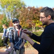
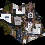
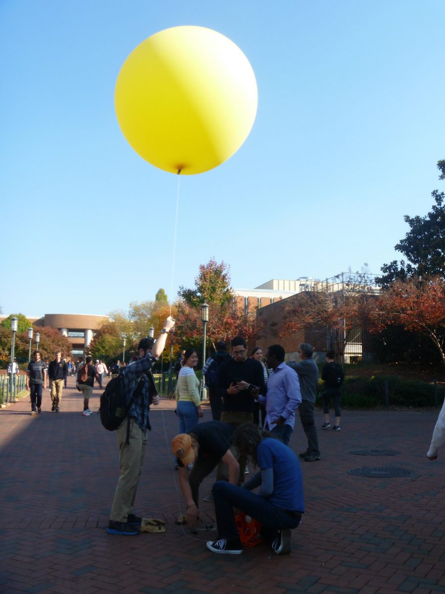
Balloon Mapping Demo
CAGIS students led a do-it-yourself remote sensing mapping demonstration for GIS Day 2016. Using a low-cost weather balloon as a platform, we collected images using a point-and-shoot camera and live video via a smart phone. Although we were nervous about suspending a phone from an altitude of 1000 ft., the mission proved successful as evidenced by the photos shown here.
About our Panel
Jonathan Clayton
Graduated from Charlotte in ’02 with a BS in Geography and a BA in Earth Science. I worked in a running store for a while, went back to take some post-bac classes to start my masters. Was offered a job at a GIS consulting company in Goldsboro; Geographic Technologies Group. I worked there four years, traveling around the country mapping different utilities for various local governments. I left there in 2009 and got a job at Comporium, a private telecommunications company in Rock Hill. I’m currently one of two GIS Analysts and have been there a little over six years. We utilize GE Smallworld, ArcGIS, QGIS, and myWorld for our web based GIS.
Scott Gregory
Mr. Gregory has 16 years of experience in geographic information systems (GIS), watershed and stormwater management planning, and natural channel design. He currently serves as an Environmental Scientist for the Asheville, NC office of Wildlands Engineering based here in Charlotte. He specializes in mapping, 3D analysis and modeling using GIS to provide spatial decision support solutions for a wide variety of water resource, ecological restoration, and environmental planning projects. Mr. Gregory’s experience includes stream design, watershed and stream geomorphic assessments, stormwater infrastructure inventories, surveying and GPS, and construction management. Prior to working as an environmental scientist, Mr. Gregory worked as a GIS Analyst for Mecklenburg County for 4 years and as a land surveyor for 3 years. His background in land surveying coupled with his Masters degree in Earth Science from UNCC (in 2004) served as springboards to entering a career focused on GIS and providing geospatial solutions.
Dale Loberger
Although Dale Loberger has earned degrees in Environmental Management, his first professional job opportunity was as a part of a team developing a utility based GIS application in Richmond, VA where he learned the unique spatial requirements of the wired telephone industry. Eventually, he had the opportunity to return to his formal education as a GIS Manager for a consulting forestry company in Charlotte where he had his first exposure to Arc/Info. Later, he would transition to Esri performing a number roles consulting in many different industries. But his predominate experience would be in local government. Finally, he has settled into the public safety sector working for Bradshaw Consulting Services. As a certified EMT and Firefighter II, he specializes in applications for improving EMS and fire service performance using GIS. He is very active in social media as “High Performance EMS” and ranks in the top 0.1% of voices worldwide on the topic of EMS. He says he was well positioned at the time GIS was still in its infancy and was willing to challenge the conventional wisdom of industry with innovative spatial thinking.
Daniel Sieger
I graduated from College of Charleston with a B.S. in Data Science, and a specialization in Geospatial technologies in 2013. I became interested in GIS while I was a computer science major at College of Charleston. I was particularly interested in raster modeling techniques for predicting sea level rise in coastal communities, due to my time in Charleston where I grew up. With my computer science background, I began using ArcGIS Server as I grew in the GIS field. After graduating, I applied and was offered a position to join ESRI as a Server Support Analyst in Esri Support. I have been using the skills learned in my GIS internship and my degree program to expand my knowledge of GIS. As a support analyst, I was able to rapidly expand my knowledge of GIS to learn about web GIS. In January 2016, I moved into my current role as Technical Lead for ArcGIS Enterprise within ESRI Support Services. I now provide technical guidance and troubleshooting support to all analysts in Esri Technical Support on ArcGIS Enterprise products. I also collaborate with our Development teams to address defects, perform trend analysis, and provide feedback on the newest releases of the software throughout the software development process. Due to my exposure to the ArcGIS Server platform (Now ArcGIS Enterprise), I expect the world of GIS to shift over the next 5 years. The world of GIS is changing, and moving towards web GIS. This is following the global shift towards web and cloud based technologies. Job prospects will continue to expand for those that expand into the world of web GIS.
Geovanny Solera
Geovanny Solera majored in Geography with a concentration in GIS and obtained an Urban Studies Minor at UNC Charlotte. After graduating Geovanny went to work for Mazda doing Marketing. Shortly thereafter he joined Esri under their Business Development sector as an Account Manager for their Utility team. From my experience at Esri I have been able to see that GIS is moving very much to the front office of businesses and organizations where GIS is no longer just for the GIS professionals but instead for everyone in the organization. With the Consumerization of IT we can only expect more people to demand easy and simple geospatial applications in their day to day life just like Google Maps has become an essential part of some people’s lives. Not only that but we see an increase of GIS in Software Mashups and in the Internet of things. GIS is trending towards the web creating a GIS facebook-like platform for people to use, create, and share maps / geospatial data from any device, anywhere, at any time. This is evident in the increase of GIS in other enterprise systems like Business Intelligence (BI), Sensor Systems, and Customer Relationship Management (CRM)