CAGIS researcher uses space-time visualizations to target outbreaks of mosquito-borne illnesses in Colombia
Charlotte, October 2018. In a new paper, CAGIS researcher and lead author Michael Desjardins describes new methods to visualize the complex, spatio-temporal dynamics of outbreaks in mosquito-born illnesses in Colombia.
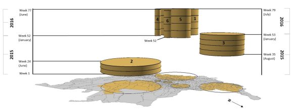
Outbreaks of chikungunya and dengue fever (both transmitted by the same two mosquitoes) occur unevenly across municipalities both geographically and in timing, presenting substaintial challenges to public health officials. Desjardins and his co-investigators Dr. Ari Whiteman (CDC – former Geography PhD student), Dr. Eric Delmelle (UNC-Charlotte Geography), and Dr. Irene Casas (Louisiana Tech) used data locating reported disease cases from the Instituto Nacional de Salud (INS), and time-space statistical approaches to map and generate 3D visualizations illustrating the size, duration, and movement of outbreak clusters.These results will be used to target public health interventions and set the stage for local-level analysis.
Desjardins, M. R., Whiteman, A., Casas, I., & Delmelle, E. (2018). Space-time clusters and co-occurrence of chikungunya and dengue fever in Colombia from 2015 to 2016. Acta tropica, 185, 77-85.
Link: https://www.sciencedirect.com/science/article/pii/S0001706X17315309